GAWAH News Desk | October 31, 2026
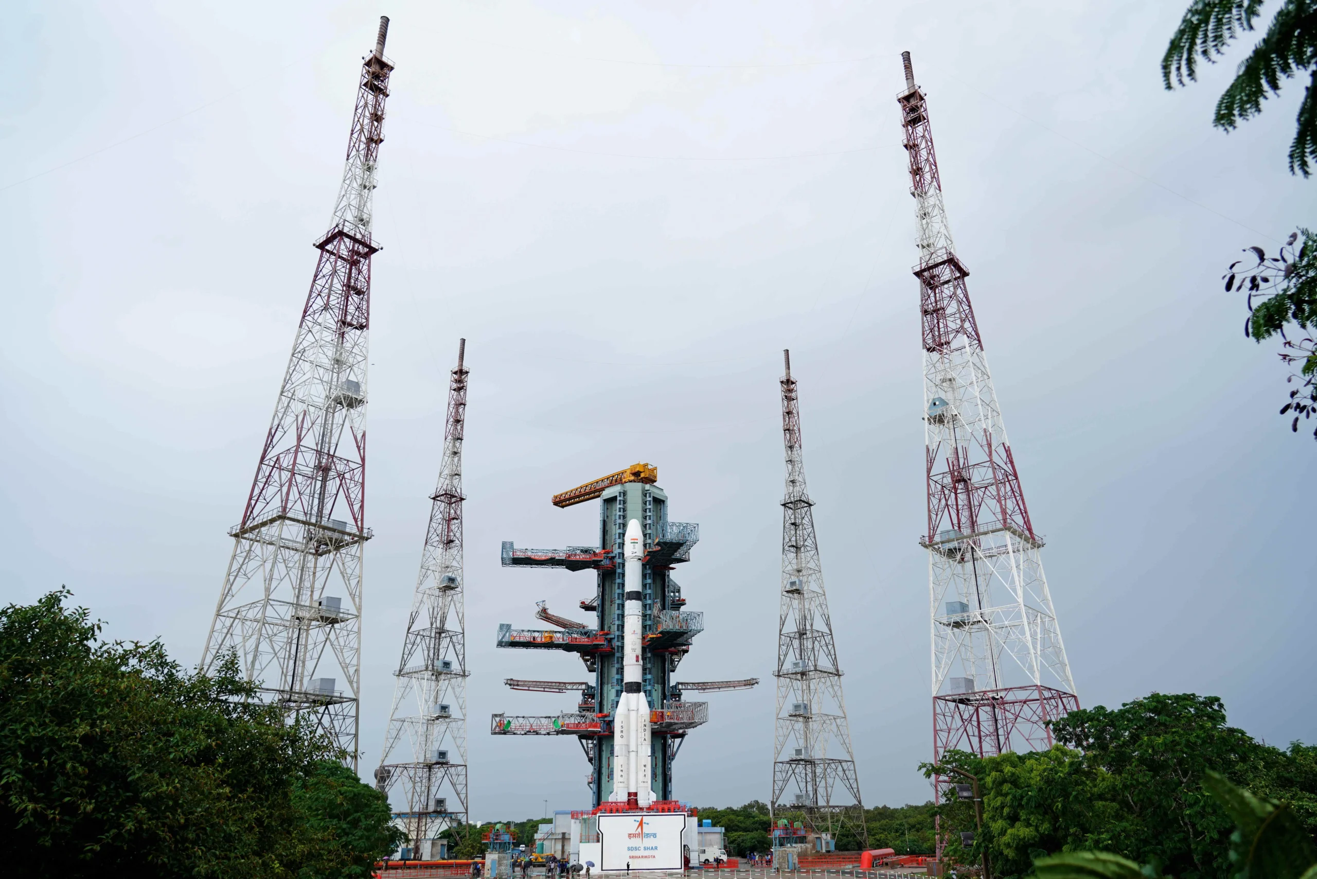
India has taken another step towards strengthening its home-grown satellite navigation network. The Indian Space Research Organisation (ISRO) says its GSLV-F18 rocket successfully placed the NVS-03 navigation satellite into a Geosynchronous Transfer Orbit after lifting off from the Satish Dhawan Space Centre at Sriharikota late on October 30.
NVS-03 is the third satellite in the next-generation Navigation with Indian Constellation (NavIC) series. It carries an indigenous atomic clock alongside procured atomic clocks and adds a civilian L1 navigation signal to the L5 and S-band signals used by the system. The mission is intended to help maintain and improve India’s independent regional positioning, navigation and timing services.
What is NVS-03 and why does it matter?
NVS-03 is part of ISRO’s second-generation navigation satellite programme. The agency says the satellite is intended to provide continuity for the Indian Regional Navigation Satellite System, now known as NavIC. GSLV-F18 was the 20th flight of India’s Geosynchronous Satellite Launch Vehicle.
Satellite navigation depends on precise timing. A receiver calculates its location by comparing the time taken for signals to arrive from multiple satellites. Atomic clocks provide the highly accurate time references needed for those calculations. NVS-03 carries an indigenously developed atomic clock as well as procured clocks, according to ISRO.
Why does NavIC need NVS-03?
The launch matters because NavIC’s satellite constellation has faced operational gaps. In a July 2026 reply to Parliament, the Centre said only three satellites were then providing positioning, navigation and timing services, while at least four operational satellites are needed for standalone positioning. The timing service was still functioning. NVS-03’s launch is a step towards rebuilding that capability, but it must reach its designated orbit and complete commissioning before it can be counted as an operational navigation satellite.
ISRO’s February 2026 review of the earlier NVS-02 mission said the satellite reached an elliptical transfer orbit, but its orbit-raising manoeuvres could not be carried out because the drive signal did not reach the oxidiser-line pyro valve. The committee identified a likely disengaged connector contact in the main and redundant circuits. ISRO said corrective measures were implemented on the later CMS-03 mission and would be followed in future missions. The history explains why NVS-03’s orbital deployment and commissioning matter as much as the successful launch itself.
For now, GSLV-F18’s success confirms that NVS-03 reached transfer orbit; it does not establish a public date for the restoration of standalone NavIC positioning services.
What is NavIC and how is it different from GPS?
NavIC — Navigation with Indian Constellation — is India’s independent regional satellite navigation system. It is designed to provide positioning, navigation and timing services across India and a region extending up to 1,500 kilometres beyond the country’s boundary. It is not a global replacement for GPS.
ISRO describes a seven-satellite constellation supported by a 24-hour ground network. NavIC provides two types of services:
- Standard Positioning Service (SPS): The civilian service intended for general users and applications.
- Restricted Service (RS): An encrypted service intended for authorised strategic users.
ISRO says NavIC signals are designed for position accuracy better than 20 metres and timing accuracy better than 50 nanoseconds in the primary service area. These are system design specifications, not a guarantee that every device will achieve the same result in every location or condition.
What is new about NVS-03’s L1 signal?
The key user-facing addition is a civilian signal in the L1 frequency band, at 1575.42 MHz. NVS-03 will add L1 to the existing L5 and S-band signals. ISRO says the NavIC L1 signal is interoperable with other global navigation satellite system signals.
L1 is widely used in satellite navigation. Adding it to NavIC can make the system easier to integrate into compatible multi-constellation receivers and consumer navigation hardware. However, the launch does not automatically make every smartphone NavIC-compatible. Support depends on the phone’s GNSS chipset, antenna design, firmware and manufacturer implementation.
Will NVS-03 improve navigation on smartphones?
Potentially, but only on devices with compatible hardware and software. A phone must be able to receive and process the relevant NavIC signals. Consumers should check the specifications published by their device manufacturer rather than assume that an existing phone will gain new NavIC capability through a routine software update.
For compatible receivers, a stronger regional navigation system can support applications such as location services, personal mobility, road and fleet navigation, aviation and marine transport, surveying, resource monitoring and precise time synchronisation.
Does the successful launch mean NavIC is fully operational?
Not by itself. ISRO has confirmed that the rocket placed NVS-03 into a Geosynchronous Transfer Orbit. The satellite must then complete the required orbital manoeuvres and in-orbit checks before it can be commissioned for navigation services. A successful launch is an important milestone, but it is not the same as confirmation that every planned service is already available to users.
NavIC is a constellation-based system. Its long-term resilience depends on the health of multiple satellites, the ground network and the timely addition of replacement spacecraft. NVS-03 is one part of that wider programme.
Where can NavIC be used?
ISRO lists applications including land, air and marine transportation, location-based services, personal mobility, resource monitoring, surveying and geodesy, scientific research, time dissemination and synchronisation, and safety-of-life alert dissemination. The agency also says NavIC’s civilian signals can work alongside signals from GPS, GLONASS, Galileo and BeiDou in compatible receivers.
Frequently asked questions
Is NavIC India’s version of GPS?
NavIC is India’s own regional satellite navigation system. Like GPS, it provides positioning and timing signals, but its primary service area is India and up to 1,500 kilometres beyond the Indian boundary rather than the entire globe.
What does the NVS-03 satellite add?
It carries an indigenous atomic clock alongside procured clocks and adds a civilian L1 signal to NavIC’s existing L5 and S-band signals.
Will all smartphones receive NavIC signals?
No. A device needs compatible satellite-navigation hardware and software. Check the manufacturer’s specifications for NavIC support.
When will NVS-03 services become available?
ISRO has confirmed the satellite’s placement into transfer orbit. Orbital manoeuvres, in-orbit checks and commissioning must follow. The mission update does not specify a public service activation date.
Official sources and further reading
- ISRO: GSLV-F18/NVS-03 mission update
- ISRO: NavIC satellite navigation services, coverage and applications
- Moneycontrol: NVS-03 launch and post-launch operations
- ISRO: NVS-02 on-orbit observations and Apex Committee recommendations, 25 February 2026
- India Today: Parliament reply on NavIC’s operational satellite count, 29 July 2026
Image credit: Indian Space Research Organisation (ISRO). The image shows GSLV-F18 on the launch pad.